September 29, Friday
North Island: From Raukumara to Whirinaki Forest parks, expect showers with possible thunderstorms, gradually clearing later tonight. Cloud cover will increase tomorrow evening, with isolated showers developing in the west. For other areas in the North Island, anticipate occasional showers, including snow down to 800 meters for a brief period tomorrow morning. Showers will transition to rain tomorrow evening with heavy precipitation. Winds will increase to westerlies, reaching gale force this afternoon and becoming severe gales tomorrow afternoon.
September 30, Saturday
North Island: Expect heavy rain with heavy falls, gradually easing to isolated showers in the evening. Snowfall may lower to 1000 meters for a time.
Strong westerly winds will change to severe gale southerlies.
South Island: Anticipate snow showers, which will become isolated and confined to the west.
Strong southwesterly winds will prevail.
October 1, Sunday
North Island: Weather conditions will be fine from Raukumara to Whirinaki Forest Parks, with a few showers elsewhere.
Gale forces southwesterly winds will gradually ease.
South Island: The Kaikoura ranges will experience fine weather. Showers will persist elsewhere, transitioning into rain.
Westerly winds will become severe in Fiordland late.
October 2, Monday
North Island: Anticipate a few showers, which may turn into rain for a period. There’s a possibility of snow lowering to 1000 meters about the Tararua Range late.
Winds will shift from west to northwest and intensify to severe gales, changing to gale force from the southwest in the south late.
South Island: Expect heavy rain with heavy falls and snow down to approximately 2200 meters. This will transition to snow showers and later become isolated rain showers.
Severe gale northwesterlies will change to severe gale southwest winds.
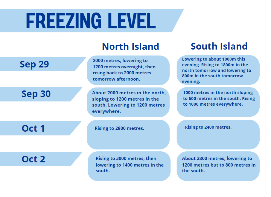
Source: MetService

